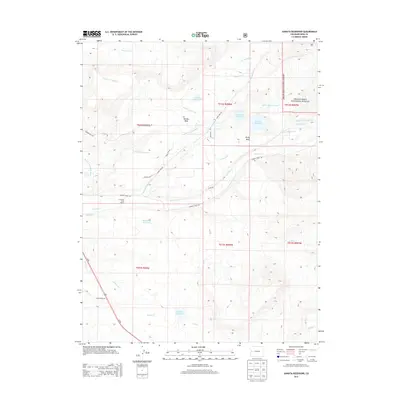
2013 Map of Juniata Reservoir
USGS Topo · Published 2013About this map
Grand Mesa National Forest defines the eastern boundary of this high-desert plateau, where complex irrigation networks dictate the patterns of rural settlement. The landscape is dominated by the flat-topped Purdy Mesa and Reeder Mesa, landforms that necessitated the construction of an intricate system of water works, including the Lander Extension Ditch, Juniata Ditch, and Bower-Ditch. These engineered waterways feed several high-altitude catchments like Juniata Reservoir and Hallenbeck Reservoir. Local ranching life is anchored by the Cross Barr Cross Ranch, situated near the confluence of the N Fork Kannah Cr and Kannah Cr. This map documents the intersection of public forest land and private ranching interests, traced by historical roads like Lands End Rd and Reeder Mesa Rd that climb through the drainage basins of Whitewater Cr and Indian Cr.
Find a feature on this map
39 named features on this map. Tap any name to fly to it.
Don’t see what you’re looking for? This feature index may not catch every label — zoom into the map to look around manually.
Map Details
Editions of this 2013 Juniata Reservoir Map
This is the sole edition of this map. No revisions or reprints were ever made.
Other maps of this area

1956 · Moab
USGS Topo · 1:250,000

1956 · Grand Junction
USGS Topo · 1:250,000

1959 · Grand Junction
USGS Topo · 1:250,000

1959 · Moab
USGS Topo · 1:250,000

1960 · Moab
USGS Topo · 1:250,000

1960 · Grand Junction
USGS Topo · 1:250,000

1962 · Moab
USGS Topo · 1:250,000

1962 · Grand Junction
USGS Topo · 1:250,000

1962 · Clifton
USGS Topo · 1:24,000
1962 · Lands End
USGS Topo · 1:24,000