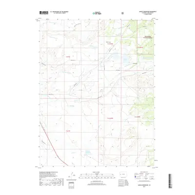
2019 Map of Juniata Reservoir
USGS Topo · Published 2019About this map
Grand Mesa National Forest defines the eastern edge of this western Colorado landscape, where the high terrain gives way to an intricate system of water management. The area is characterized by flat-topped landforms like Reeder Mesa and Purdy Mesa, which are crisscrossed by a network of historic irrigation infrastructure. Long-established water routes such as the Juniata Ditch, Lauren Ditch, and the Lander Extension Ditch illustrate the complex engineering required to sustain this arid environment. Several significant water bodies serve the region, including Juniata Reservoir, Reeder Reservoir, and McDonald Reservoir. Along the southern sections, the terrain is carved by Indian Cr and Kannah Cr, providing a contrast to the elevated mesa surfaces. This map documents a critical intersection of public forest land and the carefully managed water resources that are essential to the agricultural and natural heritage of Mesa County.
Find a feature on this map
35 named features on this map. Tap any name to fly to it.
Don’t see what you’re looking for? This feature index may not catch every label — zoom into the map to look around manually.
Map Details
Editions of this 2019 Juniata Reservoir Map
This is the sole edition of this map. No revisions or reprints were ever made.
Other maps of this area

1956 · Moab
USGS Topo · 1:250,000

1956 · Grand Junction
USGS Topo · 1:250,000

1959 · Grand Junction
USGS Topo · 1:250,000

1959 · Moab
USGS Topo · 1:250,000

1960 · Moab
USGS Topo · 1:250,000

1960 · Grand Junction
USGS Topo · 1:250,000

1962 · Moab
USGS Topo · 1:250,000

1962 · Grand Junction
USGS Topo · 1:250,000

1962 · Clifton
USGS Topo · 1:24,000
1962 · Lands End
USGS Topo · 1:24,000