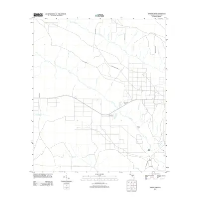
2012 Map of Juniper Creek
USGS Topo · Published 2012About this map
Juniper Cr and Fourmile Cr define the drainage of this portion of Calhoun County, where a network of graded roads and specialized landing strips indicates a landscape of rural industry and agriculture. Small private aviation facilities like Ron Wood Airport and the Steep Head Farm Airport are prominent landmarks within a terrain marked by distinctive low-lying features known locally as heads, such as Hickory Head and Buck Head. The presence of CCC Road No 16 and CCC Road No 4 points to the area's history of organized land management and forestry. To the south, the water of Little Cypress Cr moves toward the Clearwater Br, while the north is crossed by numerous named branches like Mossy Pond Br and Hogpen Br, reflecting a region defined by its intricate creek systems.
Find a feature on this map
32 named features on this map. Tap any name to fly to it.
Don’t see what you’re looking for? This feature index may not catch every label — zoom into the map to look around manually.
Map Details
Editions of this 2012 Juniper Creek Map
This is the sole edition of this map. No revisions or reprints were ever made.
Other maps of this area

1944 · Clarksville
USGS Topo · 1:31,680

1945 · Juniper Creek
USGS Topo · 1:31,680

1945 · Youngstown
USGS Topo · 1:31,680

1945 · Clarksville
USGS Topo · 1:31,680

1945 · Broad Branch
USGS Topo · 1:31,680

1945 · Frink
USGS Topo · 1:31,680

1945 · Fountain
USGS Topo · 1:31,680

1952 · Alford SE
USGS Topo · 1:24,000

1952 · Altha West
USGS Topo · 1:24,000
1952 · Compass Lake
USGS Topo · 1:24,000