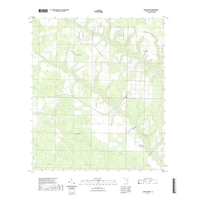
2021 Map of Juniper Creek
USGS Topo · Published 2021About this map
Juniper Cr and its many tributaries, such as Pitch Pond Br and Tossel Br, create a dense network of watercourses across this portion of Calhoun County. The landscape is defined by its low-lying, saturated basins, including the expansive Big Bear Bay, Buzzard Bay Swamp, and Old Camp Four Swamp. This hydrologic pattern reflects the classic Florida panhandle interior, where small branches like Mossy Pond Br and Hogpen Br feed into larger creek systems that have historically shaped local land use and boundaries.
Find a feature on this map
59 named features on this map. Tap any name to fly to it.
Don’t see what you’re looking for? This feature index may not catch every label — zoom into the map to look around manually.
Map Details
Editions of this 2021 Juniper Creek Map
This is the sole edition of this map. No revisions or reprints were ever made.
Other maps of this area

1944 · Clarksville
USGS Topo · 1:31,680

1945 · Juniper Creek
USGS Topo · 1:31,680

1945 · Youngstown
USGS Topo · 1:31,680

1945 · Clarksville
USGS Topo · 1:31,680

1945 · Broad Branch
USGS Topo · 1:31,680

1945 · Frink
USGS Topo · 1:31,680

1945 · Fountain
USGS Topo · 1:31,680

1952 · Alford SE
USGS Topo · 1:24,000

1952 · Altha West
USGS Topo · 1:24,000
1952 · Compass Lake
USGS Topo · 1:24,000