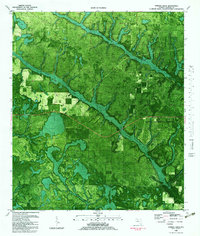
1982 Map of Juniper Creek
USGS Topo · Published 1983About this map
The Chipola Experimental Forest dominates the central landscape of this 1982 orthophotomap, showing the managed timberlands and drainage patterns of northern Calhoun County. The terrain is defined by the winding course of Juniper Creek, which is joined by numerous tributaries including Watson Branch and Hogpen Branch. This document, edited from 1970s aerial photography, provides a literal overhead view of the dense vegetation and the intricate network of water bodies such as Big Bear Bay and Cypress Creek. A Sandpit and various jeep trails indicate localized industry and access routes through the forest, while several areas are clearly marked as Private land. The orthophoto format allows researchers to distinguish between different types of ground cover and forestry practices that were in place during the early 1980s.
Find a feature on this map
13 named features on this map. Tap any name to fly to it.
Don’t see what you’re looking for? This feature index may not catch every label — zoom into the map to look around manually.
Map Details
Editions of this 1982 Juniper Creek Map
This is the sole edition of this map. No revisions or reprints were ever made.
Other maps of this area

1944 · Clarksville
USGS Topo · 1:31,680

1945 · Juniper Creek
USGS Topo · 1:31,680

1945 · Youngstown
USGS Topo · 1:31,680

1945 · Clarksville
USGS Topo · 1:31,680

1945 · Broad Branch
USGS Topo · 1:31,680

1945 · Frink
USGS Topo · 1:31,680

1945 · Fountain
USGS Topo · 1:31,680

1952 · Alford SE
USGS Topo · 1:24,000

1952 · Altha West
USGS Topo · 1:24,000
1952 · Compass Lake
USGS Topo · 1:24,000