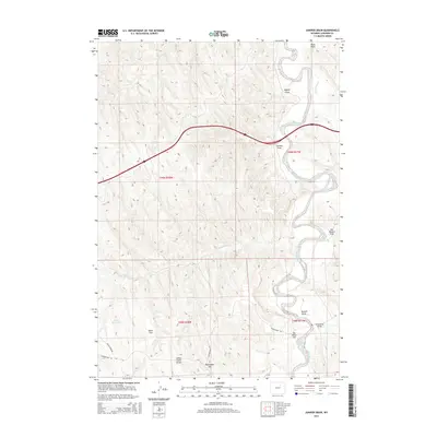
2015 Map of Juniper Draw
USGS Topo · Published 2015About this map
The Powder River meanders sharply through this high-plains landscape of Johnson County, defining a complex network of named draws and flats. The river corridor is the central geographical feature, crossed by the Schoonover Bridge which connects Schoonover Rd across the eastern bend. This 2015 survey reveals a terrain shaped by water management and transit, where Pete's Reservoir provides a vital collection point in the west. High ground is marked by the Indian Creek Divide and the prominent Monument Hill, offering significant orientation points above the drainage basins of Dead Horse Cr and Indian Cr. The map details various family-named and local landmarks, from Nines Flat and Big Mikes Flat to several distinct drainages like Bugher Draw and the eponymous Juniper Draw, illustrating the localized nomenclature of the Wyoming range.
Find a feature on this map
22 named features on this map. Tap any name to fly to it.
Don’t see what you’re looking for? This feature index may not catch every label — zoom into the map to look around manually.
Map Details
Editions of this 2015 Juniper Draw Map
This is the sole edition of this map. No revisions or reprints were ever made.
Other maps of this area

1955 · Sheridan
USGS Topo · 1:250,000

1958 · Sheridan
USGS Topo · 1:250,000

1962 · Sheridan
USGS Topo · 1:250,000
1972 · Ploessers Draw
USGS Topo · 1:24,000
1972 · Laskie Draw
USGS Topo · 1:24,000
1972 · Bear Draw
USGS Topo · 1:24,000
1972 · Somerville Flats West
USGS Topo · 1:24,000
1972 · Negro Butte
USGS Topo · 1:24,000
1972 · Bowman Flat
USGS Topo · 1:24,000
1972 · Juniper Draw
USGS Topo · 1:24,000