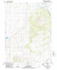
1986 Map of Juniper Mountain
USGS Topo · Published 1986About this map
Juniper Mountain dominates this portion of Moffat County, rising sharply above the winding path of the Yampa River. The landscape is defined by its drainage systems and water resources, from the high Boxelder Spring on the mountain's northern slope to the contained waters of Dry Lake Reservoir in the southwest. This mid-1980s topography reveals an area primarily shaped by natural landforms and light industrial activity, evidenced by the presence of a Gravel Pit and a lone Oil Well near the southern boundary. Steep canyons and seasonal watercourses like Juniper Canyon and Deception Creek illustrate the erosive power of the local environment. Further south, the terrain levels out into expansive gulches such as Temple Gulch and Hale Gulch, where a Storage Bin suggests a connection to the region's ranching or agricultural operations.
Find a feature on this map
11 named features on this map. Tap any name to fly to it.
Don’t see what you’re looking for? This feature index may not catch every label — zoom into the map to look around manually.
Map Details
Editions of this 1986 Juniper Mountain Map
This is the sole edition of this map. No revisions or reprints were ever made.
Other maps of this area

1907 · White River
USGS Topo · 1:125,000

1910 · Danforth Hills
USGS Topo · 1:125,000

1910 · White River
USGS Topo · 1:125,000

1912 · Axial
USGS Topo · 1:62,500

1914 · Axial
USGS Topo · 1:62,500

1916 · Craig
USGS Topo · 1:125,000

1954 · Vernal
USGS Topo · 1:250,000

1954 · Craig
USGS Topo · 1:250,000

1957 · Craig
USGS Topo · 1:250,000

1958 · Vernal
USGS Topo · 1:250,000