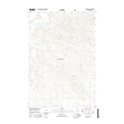
2014 Map of Juniper Spur
USGS Topo · Published 2014About this map
The Little Missouri National Grassland encompasses a significant portion of this high-plains landscape, where the Little Missouri River carves a winding course through North Dakota. The river's meanders are fed by numerous tributaries, including First Cr, Second Cr, and Sand Cr, which define the drainage patterns across the expansive terrain. The prominent landform known as Juniper Spur provides a distinctive point of elevation in an area otherwise characterized by these complex watercourse networks. Infrastructure is sparse in this protected territory, with the presence of E River Rd serving as a primary corridor for transit along the river valley. The map details a moment in time where public land management and natural hydrology dictate the character of the environment, offering a clear view of the topography before contemporary development might alter these grasslands.
Find a feature on this map
8 named features on this map. Tap any name to fly to it.
Don’t see what you’re looking for? This feature index may not catch every label — zoom into the map to look around manually.
Map Details
Editions of this 2014 Juniper Spur Map
This is the sole edition of this map. No revisions or reprints were ever made.
Other maps of this area

1953 · Dickinson
USGS Topo · 1:250,000

1957 · Dickinson
USGS Topo · 1:250,000

1961 · Rocky Ridge
USGS Topo · 1:62,500

1973 · Black Butte
USGS Topo · 1:24,000

1973 · Amidon
USGS Topo · 1:24,000

1979 · Deep Creek North
USGS Topo · 1:24,000

1979 · Bullion Butte
USGS Topo · 1:24,000

1980 · Belfield
USGS Topo · 1:100,000

1981 · Bowman
USGS Topo · 1:100,000
1982 · Cliffs Plateau
USGS Topo · 1:24,000