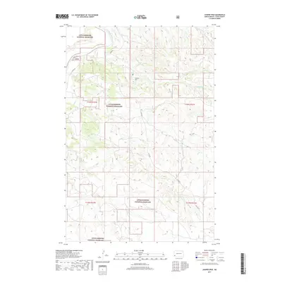
2017 Map of Juniper Spur
USGS Topo · Published 2017About this map
The Little Missouri River carves a winding path through this corner of Slope County, defining a landscape of complex drainage systems and high ridges. The Little Missouri National Grassland encompasses the majority of the terrain, where the eponymous Juniper Spur stands as a prominent topographical feature. The map details the intricate network of seasonal waterways feeding the river, including First Cr, Second Cr, Third Cr, and Sand Cr. Human presence is traced through scattered section roads and specialized routes like E River Rd, 55th St SW, and 145th Ave SW, which provide access to this protected prairie ecosystem. This document reveals the remote character of western North Dakota, illustrating the intersection of public land management and the natural breaks and coulees typical of the badlands region.
Find a feature on this map
15 named features on this map. Tap any name to fly to it.
Don’t see what you’re looking for? This feature index may not catch every label — zoom into the map to look around manually.
Map Details
Editions of this 2017 Juniper Spur Map
This is the sole edition of this map. No revisions or reprints were ever made.
Other maps of this area

1953 · Dickinson
USGS Topo · 1:250,000

1957 · Dickinson
USGS Topo · 1:250,000

1961 · Rocky Ridge
USGS Topo · 1:62,500

1973 · Black Butte
USGS Topo · 1:24,000

1973 · Amidon
USGS Topo · 1:24,000

1979 · Deep Creek North
USGS Topo · 1:24,000

1979 · Bullion Butte
USGS Topo · 1:24,000

1980 · Belfield
USGS Topo · 1:100,000

1981 · Bowman
USGS Topo · 1:100,000
1982 · Cliffs Plateau
USGS Topo · 1:24,000