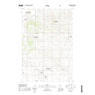
2020 Map of Juniper Spur
USGS Topo · Published 2020About this map
Little Missouri National Grassland dominates this section of Slope County, where the high plains of western North Dakota break into a complex system of drainages and spurs. The Little Missouri River carves through the northwestern corner, fed by a series of named seasonal tributaries including Sand Cr, First Cr, and Second Cr. This 2020 survey highlights the prominence of Juniper Spur, a significant local terrain feature that rises between the winding creek beds. Transport through this prairie landscape is defined by the Maah Daah Hey trail and primitive roads like E River Rd, illustrating the intersection of modern recreational access and the established public land survey system. The map provides a precise look at the township boundaries and section lines that organize this vast expanse of public grassland, making it a valuable tool for understanding the modern footprint of the Badlands.
Find a feature on this map
18 named features on this map. Tap any name to fly to it.
Don’t see what you’re looking for? This feature index may not catch every label — zoom into the map to look around manually.
Map Details
Editions of this 2020 Juniper Spur Map
This is the sole edition of this map. No revisions or reprints were ever made.
Other maps of this area

1953 · Dickinson
USGS Topo · 1:250,000

1957 · Dickinson
USGS Topo · 1:250,000

1961 · Rocky Ridge
USGS Topo · 1:62,500

1973 · Black Butte
USGS Topo · 1:24,000

1973 · Amidon
USGS Topo · 1:24,000

1979 · Deep Creek North
USGS Topo · 1:24,000

1979 · Bullion Butte
USGS Topo · 1:24,000

1980 · Belfield
USGS Topo · 1:100,000

1981 · Bowman
USGS Topo · 1:100,000
1982 · Cliffs Plateau
USGS Topo · 1:24,000