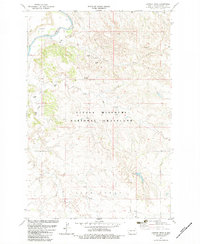
1982 Map of Juniper Spur
USGS Topo · Published 1983About this map
The Little Missouri River carves through the northwestern corner of this landscape, anchoring a region of the Little Missouri National Grassland defined by its complex drainage network and resource extraction. Significant geological and industrial markers like the Burning Coal Veins and a Scoria Pit near the river signify the subterranean activity and materials that characterize this portion of Slope County.
Find a feature on this map
17 named features on this map. Tap any name to fly to it.
Don’t see what you’re looking for? This feature index may not catch every label — zoom into the map to look around manually.
Map Details
Editions of this 1982 Juniper Spur Map
This is the sole edition of this map. No revisions or reprints were ever made.
Other maps of this area

1953 · Dickinson
USGS Topo · 1:250,000

1957 · Dickinson
USGS Topo · 1:250,000

1961 · Rocky Ridge
USGS Topo · 1:62,500

1973 · Black Butte
USGS Topo · 1:24,000

1973 · Amidon
USGS Topo · 1:24,000

1979 · Deep Creek North
USGS Topo · 1:24,000

1979 · Bullion Butte
USGS Topo · 1:24,000

1980 · Belfield
USGS Topo · 1:100,000

1981 · Bowman
USGS Topo · 1:100,000
1982 · Cliffs Plateau
USGS Topo · 1:24,000