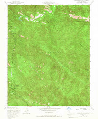
1949 Map of Junipero Serra Peak
USGS Topo · Published 1966About this map
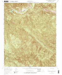
Junipero Serra Peak stands as the primary landmark of this 1949 survey, which covers a remote interior section of the Los Padres National Forest in Monterey County. The landscape is dominated by the complex drainage systems of Arroyo Seco and Santa Lucia Creek, revealing a mid-century infrastructure designed for forest management and fire prevention. A Lookout Tower atop the summit and another on Pinyon Peak overlook the high terrain, connected by the primitive Telephone Road. Human activity is concentrated at the Escondido Camp Ground and a small Airfield tucked near the banks of Arroyo Seco, highlighting the area's use for both recreation and utility. The inclusion of small water bodies like The Lakes and named drainages such as Roosevelt Creek provides specific points of interest for those studying the physical geography and historical land use of these mountains before modern development shifted the character of the region.
Find a feature on this map
17 named features on this map. Tap any name to fly to it.
Don’t see what you’re looking for? This feature index may not catch every label — zoom into the map to look around manually.
Map Details
Editions of this 1949 Junipero Serra Peak Map
5 editions found
Other maps of this area

1915 · Soledad
USGS Topo · 1:62,500

1919 · Junipero Serra
USGS Topo · 1:62,500

1920 · Jamesburg
USGS Topo · 1:48,000

1921 · Jamesburg
USGS Topo · 1:62,500

1921 · Lucia
USGS Topo · 1:62,500

1939 · Jamesburg
USGS Topo · 1:62,500

1940 · Jamesburg
USGS Topo · 1:62,500

1940 · Soledad
USGS Topo · 1:62,500

1941 · Lucia
USGS Topo · 1:62,500

1941 · Junipero Serra
USGS Topo · 1:62,500