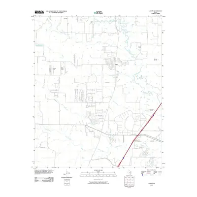
2010 Map of Justin
USGS Topo · Published 2010About this map
Justin stands as a central hub in this Denton County landscape, where the convergence of FM 156 and FM 407 anchors a community defined by its proximity to both water and flight. The northern reaches are shaped by the meandering paths of Denton Creek and Oliver Creek, while the southern portion features the historic site of Elizabethtown, accompanied by the Elizabethtown Cemetery. This 2010 survey highlights a unique density of private aviation facilities, including Propwash Airport, Flying S Farm Airport, Sitton Field, and Blue Jay Air Field, reflecting a modern era of suburban-rural transition where residential developments like those along Justin Time Airport Rd and Lone Star Cir meet established creek-fed ranchlands. Infrastructure such as the Buchannan Lake Dam on Harriet Creek and numerous watercourses like Elizabeth Creek and Henrietta Creek illustrate the managed hydrology of the region north of Fort Worth.
Find a feature on this map
59 named features on this map. Tap any name to fly to it.
Don’t see what you’re looking for? This feature index may not catch every label — zoom into the map to look around manually.
Map Details
Editions of this 2010 Justin Map
This is the sole edition of this map. No revisions or reprints were ever made.
Other maps of this area

1894 · Fort Worth
USGS Topo · 1:125,000

1931 · Grapevine
USGS Topo · 1:62,500

1954 · Dallas
USGS Topo · 1:250,000

1954 · Sherman
USGS Topo · 1:250,000

1955 · Avondale
USGS Topo · 1:24,000

1955 · Keller
USGS Topo · 1:24,000

1955 · Haltom City
USGS Topo · 1:62,500

1958 · Dallas
USGS Topo · 1:250,000

1958 · Sherman
USGS Topo · 1:250,000
1959 · Colleyville
USGS Topo · 1:24,000