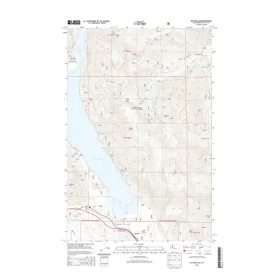
2014 Map of Kachess Lake
USGS Topo · Published 2014About this map
Kachess Lake dominates the western portion of this 2014 survey, illustrating the convergence of high-mountain hydrology and infrastructure in Kittitas County. The landscape is defined by the sharp rise of Kachess Ridge and Easton Ridge, which wall in the basin where the Kachess River and Yakima River meet. At the southern end of the lake, the settlement of Easton serves as a hub for both aviation and mountain access, evidenced by the Easton State Airport and nearby Easton Sno-Park.
Find a feature on this map
43 named features on this map. Tap any name to fly to it.
Don’t see what you’re looking for? This feature index may not catch every label — zoom into the map to look around manually.
Map Details
Editions of this 2014 Kachess Lake Map
This is the sole edition of this map. No revisions or reprints were ever made.
Other maps of this area

1901 · Snoqualmie Pass
USGS Topo · 1:125,000

1903 · Snoqualmie
USGS Topo · 1:125,000

1957 · Wenatchee
USGS Topo · 1:250,000

1961 · Snoqualmie Pass
USGS Topo · 1:62,500

1961 · Easton
USGS Topo · 1:62,500

1961 · Kachess Lake
USGS Topo · 1:62,500

1962 · Lester
USGS Topo · 1:62,500

1975 · Snoqualmie Pass
USGS Topo · 1:100,000

1989 · Easton
USGS Topo · 1:24,000
1989 · Ronald
USGS Topo · 1:24,000