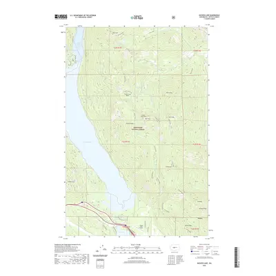
2020 Map of Kachess Lake
USGS Topo · Published 2020About this map
Kachess Lake and the smaller Little Kachess Lake dominate this portion of the Wenatchee National Forest, where steep ridgelines descend into glacial valleys. The settlement of Lake Easton sits at the southern end of the sheet, serving as a gateway to the mountains where Kachess River Rd and Lake Ridge Rd provide access to the waterfront. The surrounding peaks, including Amabilis Mtn, Thorp Mtn, and Domerie Peak, define the watershed for numerous creeks like French Cabin Creek and Silver Creek.
Find a feature on this map
49 named features on this map. Tap any name to fly to it.
Don’t see what you’re looking for? This feature index may not catch every label — zoom into the map to look around manually.
Map Details
Editions of this 2020 Kachess Lake Map
This is the sole edition of this map. No revisions or reprints were ever made.
Other maps of this area

1901 · Snoqualmie Pass
USGS Topo · 1:125,000

1903 · Snoqualmie
USGS Topo · 1:125,000

1957 · Wenatchee
USGS Topo · 1:250,000

1961 · Snoqualmie Pass
USGS Topo · 1:62,500

1961 · Easton
USGS Topo · 1:62,500

1961 · Kachess Lake
USGS Topo · 1:62,500

1962 · Lester
USGS Topo · 1:62,500

1975 · Snoqualmie Pass
USGS Topo · 1:100,000

1989 · Easton
USGS Topo · 1:24,000
1989 · Ronald
USGS Topo · 1:24,000