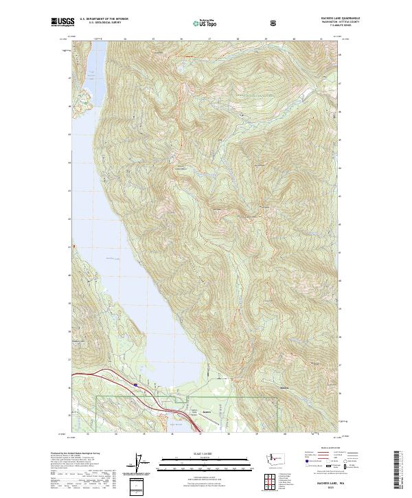
2023 Map of Kachess Lake
USGS Topo · Published 2023About this map
Easton serves as the primary hub in this mountain corridor, situated where the Yakima River feeds into Lake Easton. The landscape is dominated by the steep topography of the Wenatchee National Forest, with Kachess Lake stretching northward into a labyrinth of peaks and timbered basins. The map captures a complex network of recreational and historic paths, including the Iron Horse Trl following the old rail grade and the Kachess Ridge Trl tracing the high ground east of the water. High-elevation points like Thorp Mtn and Amabilis Mtn anchor the ridgelines, while the Easton State Airport provides a modern navigational landmark in the valley floor. The geography here illustrates the intersection of vital water resources and the transport routes that have historically connected the Cascades to the eastern plains.
Find a feature on this map
52 named features on this map. Tap any name to fly to it.
Don’t see what you’re looking for? This feature index may not catch every label — zoom into the map to look around manually.
Map Details
Editions of this 2023 Kachess Lake Map
This is the sole edition of this map. No revisions or reprints were ever made.
Other maps of this area

1901 · Snoqualmie Pass
USGS Topo · 1:125,000

1903 · Snoqualmie
USGS Topo · 1:125,000

1957 · Wenatchee
USGS Topo · 1:250,000

1961 · Snoqualmie Pass
USGS Topo · 1:62,500

1961 · Easton
USGS Topo · 1:62,500

1961 · Kachess Lake
USGS Topo · 1:62,500

1962 · Lester
USGS Topo · 1:62,500

1975 · Snoqualmie Pass
USGS Topo · 1:100,000

1989 · Easton
USGS Topo · 1:24,000
1989 · Ronald
USGS Topo · 1:24,000