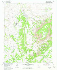
1981 Map of Kaibito
USGS Topo · Published 1982About this map
The high desert plateau of the Navajo Indian Reservation centers on the community of Kaibito, documented here in the early 1980s. The settlement's institutional history is anchored by the Kaibito Boarding Sch and the nearby Old Kaibito Boarding Sch, indicating the educational infrastructure of the period. Essential water sources, critical in this arid environment, are clearly marked at Juniper Well, Kaibito Springs, and Shonto Spring, while a series of Sewage Disposal Ponds and Water Tanks trace the modernizing utilities of the township.
Find a feature on this map
22 named features on this map. Tap any name to fly to it.
Don’t see what you’re looking for? This feature index may not catch every label — zoom into the map to look around manually.
Map Details
Editions of this 1981 Kaibito Map
This is the sole edition of this map. No revisions or reprints were ever made.
Other maps of this area

1883 · Marsh Pass
USGS Topo · 1:250,000

1886 · Echo Cliffs
USGS Topo · 1:250,000

1891 · Echo Cliffs
USGS Topo · 1:250,000

1892 · Marsh Pass
USGS Topo · 1:250,000

1956 · Marble Canyon
USGS Topo · 1:250,000

1959 · Marble Canyon
USGS Topo · 1:250,000

1961 · Marble Canyon
USGS Topo · 1:250,000

1970 · Square Butte
USGS Topo · 1:24,000
1970 · Two Red Mesas
USGS Topo · 1:24,000
1970 · White Mesa Arch
USGS Topo · 1:24,000