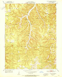
1951 Map of Kaintuck Hollow
USGS Topo · Published 1951About this map
Mark Twain National Forest dominates this mid-century landscape in Phelps County, where the rugged topography of the Ozarks is defined by deep drainages and spring-fed streams. The map reveals a dispersed rural community organized around water sources and small social centers, such as Mill Creek Ch and Kaintuck Ch. Notable hydrological features include Wilkins Spring and Yelton Spring, which feed into Mill Creek. The surveyor's notes indicate the shifting nature of local education and infrastructure during this period, marking the Western Star Sch (Abandoned) while several other schoolhouses remain active. Strategic vantage points are established at the Knotwell Lookout Tower and Corn Creek Lookout Tower, serving as vital fire-watch stations for the surrounding timberlands. Distinctive geological formations like the Natural Bridge and King Sink further characterize the karst-heavy environment of this drainage basin.
Find a feature on this map
29 named features on this map. Tap any name to fly to it.
Don’t see what you’re looking for? This feature index may not catch every label — zoom into the map to look around manually.
Map Details
Editions of this 1951 Kaintuck Hollow Map
2 editions found
Other maps of this area

1912 · Rolla
USGS Topo · 1:62,500

1936 · Waynesville
USGS Topo · 1:48,000

1937 · Edgar Springs
USGS Topo · 1:48,000

1941 · Big Piney
USGS Topo · 1:62,500

1942 · Waynesville
USGS Topo · 1:62,500

1943 · Big Piney
USGS Topo · 1:62,500

1944 · Waynesville
USGS Topo · 1:62,500

1945 · Edgar Springs
USGS Topo · 1:62,500

1949 · Rolla
USGS Topo · 1:250,000

1950 · Newburg
USGS Topo · 1:24,000