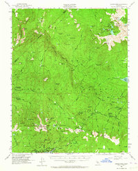
1953 Map of Kaiser Peak
USGS Topo · Published 1964About this map
The South Fork San Joaquin River and its rugged alpine tributaries define this high-altitude survey of the Sierra National Forest. This era shows the landscape at a point of increasing accessibility for recreation and resource management, evidenced by the infrastructure at Mono Hot Springs and the numerous guard stations like Kaiser Diggings Guard Station and Heitz Meadow Guard Sta. The map captures the spillway of Lake Thomas A. Edison, a massive hydroelectric project on Mono Creek.
Find a feature on this map
121 named features on this map. Tap any name to fly to it.
Don’t see what you’re looking for? This feature index may not catch every label — zoom into the map to look around manually.
Map Details
Editions of this 1953 Kaiser Peak Map
5 editions found

Other maps of this area

1901 · Mt. Lyell
USGS Topo · 1:125,000

1904 · Kaiser
USGS Topo · 1:125,000

1912 · Mt. Goddard
USGS Topo · 1:125,000

1914 · Mt. Morrison
USGS Topo · 1:125,000

1947 · Mariposa
USGS Topo · 1:250,000

1948 · Mariposa
USGS Topo · 1:250,000

1953 · Mt. Morrison
USGS Topo · 1:62,500

1953 · Merced Peak
USGS Topo · 1:62,500

1953 · Mt Abbot
USGS Topo · 1:62,500

1953 · Devils Postpile
USGS Topo · 1:62,500