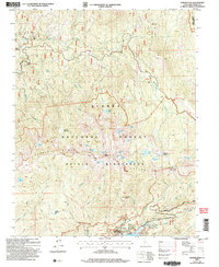
2004 Map of Kaiser Peak
USGS Topo · Published 2007About this map
Kaiser Diggings stands as a testament to the high-country activity within the Sierra National Forest during this 2004 revision. The landscape is defined by the sharp elevations of Kaiser Ridge and the prominent Kaiser Peak, which tower over a network of alpine lakes such as George Lake, Jewel Lake, and Nellie Lake. These water bodies, along with extensive high-mountain meadows like Gloria Meadow and Sample Meadow, illustrate the hydrologic character of the Kaiser Wilderness.
Find a feature on this map
66 named features on this map. Tap any name to fly to it.
Don’t see what you’re looking for? This feature index may not catch every label — zoom into the map to look around manually.
Map Details
Editions of this 2004 Kaiser Peak Map
2 editions found
Other maps of this area

1904 · Kaiser
USGS Topo · 1:125,000

1947 · Mariposa
USGS Topo · 1:250,000

1948 · Mariposa
USGS Topo · 1:250,000

1953 · Huntington Lake
USGS Topo · 1:62,500

1953 · Shaver Lake
USGS Topo · 1:62,500

1953 · Shuteye Peak
USGS Topo · 1:62,500

1953 · Kaiser Peak
USGS Topo · 1:62,500

1957 · Mariposa
USGS Topo · 1:250,000

1963 · Mariposa
USGS Topo · 1:250,000

1980 · Shaver Lake
USGS Topo · 1:100,000