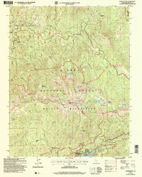
2004 Map of Kaiser Peak
USGS Topo · Published 2007About this map
Kaiser Peak towers over a landscape defined by high-altitude glacial lakes and historical resource extraction at the start of the 21st century. The map details the transition from the recreation-heavy shoreline of Huntington Lake in the south, featuring the Eastwood Visitor Center and D&F Packstation, to the protected wilderness of the Kaiser Ridge. The northern slopes reveal the legacy of early mining efforts at Kaiser Diggings and West Kaiser, while the interior of the Kaiser Wilderness is dotted with numerous small alpine basins such as George Lake, Jewel Lake, and Nellie Lake. This survey captures the region just as modern forestry management and recreational infrastructure, including the Kokanee Work Center and the Potter Pass Byway, became established fixtures in the Sierra National Forest.
Find a feature on this map
50 named features on this map. Tap any name to fly to it.
Don’t see what you’re looking for? This feature index may not catch every label — zoom into the map to look around manually.
Map Details
Editions of this 2004 Kaiser Peak Map
2 editions found
Other maps of this area

1904 · Kaiser
USGS Topo · 1:125,000

1947 · Mariposa
USGS Topo · 1:250,000

1948 · Mariposa
USGS Topo · 1:250,000

1953 · Huntington Lake
USGS Topo · 1:62,500

1953 · Shaver Lake
USGS Topo · 1:62,500

1953 · Shuteye Peak
USGS Topo · 1:62,500

1953 · Kaiser Peak
USGS Topo · 1:62,500

1957 · Mariposa
USGS Topo · 1:250,000

1963 · Mariposa
USGS Topo · 1:250,000

1980 · Shaver Lake
USGS Topo · 1:100,000