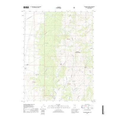
2018 Map of Kalamazoo Summit
USGS Topo · Published 2018About this map
Steptoe Valley forms the western boundary of this high-altitude landscape, where the terrain rises sharply into the Schell Creek Range. This 2018 survey captures a complex network of forest development roads and specialized pathways such as the Birds Beak Loop and the Ditch Creek Trail, which navigate the steep drainage systems of Kalamazoo Cr and Fitzhugh Cr. The map is characterized by its numerous seasonal and perennial water sources, including the creatively named Ice Cream Springs and Oil Springs, which have long served as vital landmarks in this arid environment.
Find a feature on this map
41 named features on this map. Tap any name to fly to it.
Don’t see what you’re looking for? This feature index may not catch every label — zoom into the map to look around manually.
Map Details
Editions of this 2018 Kalamazoo Summit Map
This is the sole edition of this map. No revisions or reprints were ever made.
Other maps of this area

1952 · Ely
USGS Topo · 1:125,000

1956 · Ely
USGS Topo · 1:250,000

1958 · McGill
USGS Topo · 1:24,000

1958 · McGill
USGS Topo · 1:62,500

1959 · Ely
USGS Topo · 1:250,000

1959 · Schell Peaks
USGS Topo · 1:62,500

1963 · Ely
USGS Topo · 1:250,000

1981 · North Schell Peak
USGS Topo · 1:24,000

1981 · Duck Creek Valley
USGS Topo · 1:24,000
1982 · Kalamazoo Creek
USGS Topo · 1:24,000