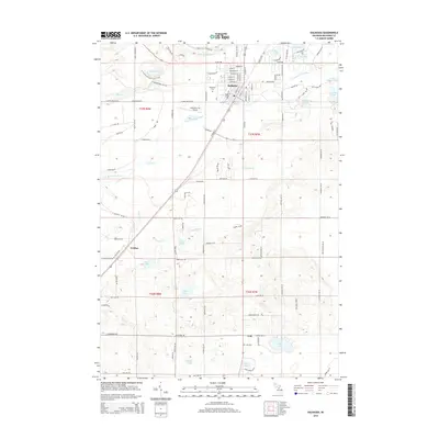
2014 Map of Kalkaska
USGS Topo · Published 2014About this map
The glacial landscape of Kalkaska and its surrounding townships is defined by an intricate network of kettle lakes and river headwaters. Centered on the village at the junction of several regional routes, the area shows a distinct transition from the organized street grid of the town center to the dispersed settlements of Crofton and Lodi. Notable water bodies like Blue Lake, Loon Lake, and Bass Lake dot the terrain, while the N Br Boardman River and the Little Rapid River drain the northern reaches. For local historians and genealogists, the map preserves the locations of Evergreen Cem and Lodi Cem, along with the route of the N Country National Scenic Trail. The presence of the Kalkaska City Airport and various localized road networks such as Smith Lake Rd NW and Boardman Rd highlights the community's modern infrastructure within this water-rich environment.
Find a feature on this map
105 named features on this map. Tap any name to fly to it.
Don’t see what you’re looking for? This feature index may not catch every label — zoom into the map to look around manually.
Map Details
Editions of this 2014 Kalkaska Map
This is the sole edition of this map. No revisions or reprints were ever made.
Other maps of this area

1954 · Traverse City
USGS Topo · 1:250,000

1956 · Mancelona
USGS Topo · 1:62,500

1956 · Kalkaska
USGS Topo · 1:62,500

1956 · Fife Lake
USGS Topo · 1:62,500

1957 · Elk Rapids
USGS Topo · 1:62,500

1958 · Traverse City
USGS Topo · 1:250,000

1983 · Traverse City
USGS Topo · 1:100,000
1983 · Torch River
USGS Topo · 1:24,000
1985 · Kalkaska
USGS Topo · 1:24,000
1985 · Sharon
USGS Topo · 1:24,000