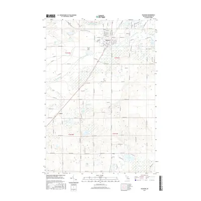
2017 Map of Kalkaska
USGS Topo · Published 2017About this map
Kalkaska serves as the central hub of this northern Michigan landscape, where the street grid meets the Kalkaska City Airport and the corridor of the Little Rapid River. The area is defined by its glacial hydrology, featuring a dense network of water bodies including Loon Lake, Bass Lake, and Kettle Lake. To the west, the settlement of Crofton is bordered by the expansive Crofton Swamp, illustrating the persistence of wetlands amidst the regional transport network. Long-distance recreation is represented by the N Country Trail;Iron Belle Trail, which cuts across the northern townships. The map provides a detailed view of the local infrastructure, from the small hamlet of Lodi and its namesake Lodi Cemetery to the established Evergreen Cemetery near the heart of the village. The drainage patterns of the North Branch Boardman River further characterize the interplay between the highland terrain and the valley floor.
Find a feature on this map
140 named features on this map. Tap any name to fly to it.
Don’t see what you’re looking for? This feature index may not catch every label — zoom into the map to look around manually.
Map Details
Editions of this 2017 Kalkaska Map
This is the sole edition of this map. No revisions or reprints were ever made.
Other maps of this area

1954 · Traverse City
USGS Topo · 1:250,000

1956 · Mancelona
USGS Topo · 1:62,500

1956 · Kalkaska
USGS Topo · 1:62,500

1956 · Fife Lake
USGS Topo · 1:62,500

1957 · Elk Rapids
USGS Topo · 1:62,500

1958 · Traverse City
USGS Topo · 1:250,000

1983 · Traverse City
USGS Topo · 1:100,000
1983 · Torch River
USGS Topo · 1:24,000
1985 · Kalkaska
USGS Topo · 1:24,000
1985 · Sharon
USGS Topo · 1:24,000