
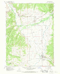
1967 Map of Kamas
USGS Topo · Published 1969About this map
Rhodes Valley serves as the central pastoral corridor of this 1960s survey, where agricultural life is anchored by the Weber River. The map documents a cluster of rural communities including Peoa, Oakley, and Marion, each supported by its own local burial ground such as Stevens Cem and Marion Cem. In the southern portion of the valley, the town of Kamas appears as the primary population center, featuring the South Summit HS and a specialized irrigation network that includes the Provo River Diversion Canal. To the west, the landscape rises sharply into the West Hills, a region marked by numerous drainage systems like Jensen Hollow and Rock Hollow. This map captures the intersection of traditional livestock ranching and the managed water systems essential for high-altitude valley farming, bordered by the protected lands of the Wasatch Nat For.
Find a feature on this map
42 named features on this map. Tap any name to fly to it.
Don’t see what you’re looking for? This feature index may not catch every label — zoom into the map to look around manually.
Map Details
Editions of this 1967 Kamas Map
2 editions found
Other maps of this area

1885 · Salt Lake
USGS Topo · 1:250,000

1900 · Coalville
USGS Topo · 1:125,000

1903 · Coalville
USGS Topo · 1:125,000

1954 · Salt Lake City
USGS Topo · 1:250,000

1955 · Heber
USGS Topo · 1:24,000

1955 · Park City East
USGS Topo · 1:24,000

1958 · Salt Lake City
USGS Topo · 1:250,000

1960 · Salt Lake City
USGS Topo · 1:250,000

1967 · Francis
USGS Topo · 1:24,000
1967 · Wanship
USGS Topo · 1:24,000