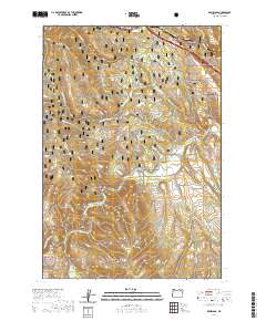
2020 Map of Kamela SE
USGS Topo · Published 2020About this map
Whitman National Forest land dominates this section of Union County, where the Grande Ronde River carves a path through a landscape defined by significant elevation changes. This 2020 edition reveals a geography heavily utilized for modern recreation, featuring the 21 Road Snowmobile (Snow) and an extensive network of cycling trails including Spring Creek Bike Loop B and Spring Creek Bike Loop D.
Find a feature on this map
25 named features on this map. Tap any name to fly to it.
Don’t see what you’re looking for? This feature index may not catch every label — zoom into the map to look around manually.
Map Details
Editions of this 2020 Kamela SE Map
This is the sole edition of this map. No revisions or reprints were ever made.
Other maps of this area

1953 · Pendleton
USGS Topo · 1:250,000

1956 · Pendleton
USGS Topo · 1:250,000

1963 · Meacham Lake
USGS Topo · 1:24,000

1963 · Hilgard
USGS Topo · 1:24,000

1964 · Mc Intyre Creek
USGS Topo · 1:24,000

1964 · Huron
USGS Topo · 1:24,000

1964 · Drumhill Ridge
USGS Topo · 1:24,000

1964 · Kamela SE
USGS Topo · 1:24,000

1965 · Marley Creek
USGS Topo · 1:24,000

1965 · Little Beaver Creek
USGS Topo · 1:24,000