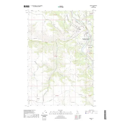
2020 Map of Kamiah
USGS Topo · Published 2020About this map
The Clearwater River serves as the focal point for this Idaho landscape, carving through the terrain where Lewis Co meets Idaho Co. The valley floor is home to the established settlements of Kamiah and East Kamiah, while the higher plateaus to the southwest support the community of Winona. This area is deeply significant for its cultural landscape, indicated by the presence of the Nez Perce National Historical Park and several historic burial grounds including Teh Lapa Low Cem and Nikesa Cem.
Find a feature on this map
67 named features on this map. Tap any name to fly to it.
Don’t see what you’re looking for? This feature index may not catch every label — zoom into the map to look around manually.
Map Details
Editions of this 2020 Kamiah Map
This is the sole edition of this map. No revisions or reprints were ever made.
Other maps of this area

1924 · Kamiah
USGS Topo · 1:125,000

1924 · Weippe
USGS Topo · 1:125,000

1955 · Pullman
USGS Topo · 1:250,000

1956 · Hamilton
USGS Topo · 1:250,000

1958 · Pullman
USGS Topo · 1:250,000

1959 · Hamilton
USGS Topo · 1:250,000

1960 · Hamilton
USGS Topo · 1:250,000

1964 · Hamilton
USGS Topo · 1:250,000

1966 · Kooskia
USGS Topo · 1:24,000
1966 · Stites
USGS Topo · 1:24,000