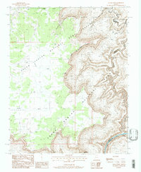
1988 Map of Kanab Point
USGS Topo · Published 1988About this map
Kanab Point stands as a prominent overlook above the deep canyons of northern Arizona, situated where the high plateaus meet the intricate drainage systems of the Colorado River. This late-1980s survey illustrates a landscape defined by federal land management, capturing the intersection of Grand Canyon National Park, the Kaibab National Forest, and the Kanab Creek Game Preserve. The topography is marked by significant elevation drops from the rim down toward the Kanab Rapids, with intermittent water sources such as Showerbath Spring and North Spring providing critical points of interest in this arid environment. The map details the complex network of side canyons like Chamberlain Canyon and the winding course of Robinson Wash, showing the region's natural geography before modern environmental shifts altered these remote drainage patterns.
Find a feature on this map
18 named features on this map. Tap any name to fly to it.
Don’t see what you’re looking for? This feature index may not catch every label — zoom into the map to look around manually.
Map Details
Editions of this 1988 Kanab Point Map
2 editions found
Other maps of this area

1886 · Kaibab
USGS Topo · 1:250,000

1953 · Grand Canyon
USGS Topo · 1:250,000

1954 · Heaton Knolls SE
USGS Topo · 1:24,000

1954 · Heaton Knolls
USGS Topo · 1:62,500

1957 · Grand Canyon
USGS Topo · 1:250,000

1957 · Jumpup Canyon
USGS Topo · 1:62,500

1958 · Grand Canyon
USGS Topo · 1:250,000

1960 · Grand Canyon
USGS Topo · 1:250,000

1962 · Kanab Point
USGS Topo · 1:62,500

1962 · Tuckup Canyon
USGS Topo · 1:62,500