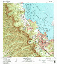
1983 Map of Kaneohe
USGS Topo · Published 1983About this map
The windward side of Oahu, defined by the sharp ridges of the Honolulu Watershed Forest Reserve, meets the intricate coastline of Kaneohe Bay in this 1983 revision. The landscape reflects a mix of suburban expansion and preserved cultural sites, notably the Byodo-In Temple within the Valley of the Temples Mem Park. Urban centers like Kaneohe and Puoala Village are linked by the Kamehameha Highway and Likelike Highway, which provide access through the dramatic vertical relief of peaks like Puu Keahiakahoe. Along the shore, the military presence at the Kaneohe Bay Marine Corps Air Station stands alongside research and recreation areas, including the University of Hawaii Marine Laboratory on Moku o Loe. Further north, agricultural roots remain visible in the Waiahole Homesteads and the small coastal cluster at Waikane.
Find a feature on this map
63 named features on this map. Tap any name to fly to it.
Don’t see what you’re looking for? This feature index may not catch every label — zoom into the map to look around manually.
Map Details
Editions of this 1983 Kaneohe Map
2 editions found
Other maps of this area

1952 · Koko Head
USGS Topo · 1:24,000

1952 · Mokapu
USGS Topo · 1:24,000

1953 · Honolulu
USGS Topo · 1:24,000

1953 · Puuloa
USGS Topo · 1:24,000

1953 · Hauula
USGS Topo · 1:24,000

1954 · Oahu
USGS Topo · 1:250,000

1954 · Kahana
USGS Topo · 1:24,000

1954 · Kaneohe
USGS Topo · 1:24,000

1954 · Waipahu
USGS Topo · 1:24,000

1959 · Mokapu
USGS Topo · 1:24,000