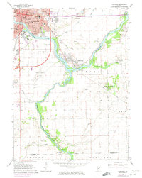
1964 Map of Kankakee
USGS Topo · Published 1974About this map
The confluence of the Kankakee River and the Iroquois River anchors this mid-century survey of Kankakee County, Illinois. The city of Kankakee dominates the northwestern corner, characterized by its dense network of educational and institutional landmarks including St Joseph Seminary, Mark Twain Sch, and the extensive grounds of the Kankakee State Hospital. Evidence of the region's psychiatric care history is visible through the Old State Hospital Cem and State Hospital Cem near the riverbanks. Moving southeast, the landscape transitions into the residential area of Aroma Park and the agricultural reaches of St Anne and Papineau. Transportation infrastructure, including the Penn Central rail line and the Greater Kankakee Airport, highlights the area's mid-century connectivity, while small settlements like Sugar Island remain along the winding waterways.
Find a feature on this map
54 named features on this map. Tap any name to fly to it.
Don’t see what you’re looking for? This feature index may not catch every label — zoom into the map to look around manually.
Map Details
Editions of this 1964 Kankakee Map
2 editions found
Other maps of this area

1922 · Momence
USGS Topo · 1:62,500

1922 · Kankakee
USGS Topo · 1:62,500

1924 · Momence
USGS Topo · 1:62,500

1924 · Kankakee
USGS Topo · 1:62,500

1935 · Watseka
USGS Topo · 1:48,000

1939 · Watseka
USGS Topo · 1:62,500

1944 · Gilman
USGS Topo · 1:62,500

1946 · Gilman
USGS Topo · 1:62,500

1953 · Chicago
USGS Topo · 1:250,000

1953 · Danville
USGS Topo · 1:250,000