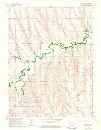
1965 Map of Kanona NE
USGS Topo · Published 1966About this map
Sappa Creek meanders deeply across this High Plains landscape, its winding course defining the agricultural and industrial character of the region during the mid-1960s. The terrain is marked by the distinct boundaries of Harlan, Grant, Roosevelt, and Lincoln townships, where the land-use pattern transitions between cultivated fields and resource extraction. Evidence of the local economy is visible in the Warner Oil Field and scattered oil wells, alongside several gravel pits that suggest active infrastructure development. For genealogists and local historians, the presence of the White Cem provides a specific point of reference within this rural Decatur County landscape. This survey was produced as part of the Department of the Interior's efforts for the development of the Missouri River Basin, reflecting a period of systematic mapping and resource management in western Kansas.
Find a feature on this map
11 named features on this map. Tap any name to fly to it.
Don’t see what you’re looking for? This feature index may not catch every label — zoom into the map to look around manually.
Map Details
Editions of this 1965 Kanona NE Map
This is the sole edition of this map. No revisions or reprints were ever made.
Other maps of this area

1951 · Norcatur
USGS Topo · 1:62,500

1951 · Kanona
USGS Topo · 1:62,500

1954 · McCook
USGS Topo · 1:250,000

1954 · Goodland
USGS Topo · 1:250,000

1956 · Goodland
USGS Topo · 1:250,000

1957 · McCook
USGS Topo · 1:250,000

1957 · Goodland
USGS Topo · 1:250,000

1957 · Shippee
USGS Topo · 1:24,000

1957 · Danbury
USGS Topo · 1:24,000

1957 · Lebanon
USGS Topo · 1:24,000