
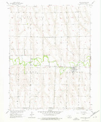
1957 Map of Lebanon
USGS Topo · Published 1958About this map
Beaver Creek meanders through the heart of this landscape, defining the valley floor where the settlement of Lebanon took root. In the late 1950s, the community functioned as a local hub for this rural stretch of the Nebraska-Kansas border, situated along the Chicago Burlington and Quincy railroad line. This transportation corridor was essential for moving goods across the flat valley bottom, overlooked to the north by the prominent elevation of Missouri Ridge.
Find a feature on this map
13 named features on this map. Tap any name to fly to it.
Don’t see what you’re looking for? This feature index may not catch every label — zoom into the map to look around manually.
Map Details
Editions of this 1957 Lebanon Map
3 editions found
Other maps of this area

1951 · Norcatur
USGS Topo · 1:62,500

1951 · Kanona
USGS Topo · 1:62,500

1954 · McCook
USGS Topo · 1:250,000

1954 · Goodland
USGS Topo · 1:250,000

1956 · Goodland
USGS Topo · 1:250,000

1957 · McCook
USGS Topo · 1:250,000

1957 · Goodland
USGS Topo · 1:250,000

1957 · Shippee
USGS Topo · 1:24,000

1957 · Danbury
USGS Topo · 1:24,000

1957 · Danbury NE
USGS Topo · 1:24,000