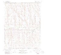
1957 Map of Lebanon
USGS Topo · Published 1983About this map
The village of Lebanon sits along the winding valley of Beaver Creek in the southwest corner of Red Willow County, just north of the Nebraska Kansas state line. This landscape, surveyed in the mid-20th century as part of the Missouri River Basin development program, is defined by the east-west corridor of the Burlington Northern railroad. The agricultural character of the era is evidenced by local landmarks such as Hamburg Cem and Redman Cem, which anchor the rural sections surrounding the town site. The map provides a detailed view of the section lines and topography at a time when the railroad remained the primary pulse of transport through these prairie creek bottoms.
Find a feature on this map
7 named features on this map. Tap any name to fly to it.
Don’t see what you’re looking for? This feature index may not catch every label — zoom into the map to look around manually.
Map Details
Editions of this 1957 Lebanon Map
3 editions found
Other maps of this area

1951 · Norcatur
USGS Topo · 1:62,500

1951 · Kanona
USGS Topo · 1:62,500

1954 · McCook
USGS Topo · 1:250,000

1954 · Goodland
USGS Topo · 1:250,000

1956 · Goodland
USGS Topo · 1:250,000

1957 · McCook
USGS Topo · 1:250,000

1957 · Goodland
USGS Topo · 1:250,000

1957 · Shippee
USGS Topo · 1:24,000

1957 · Danbury
USGS Topo · 1:24,000

1957 · Lebanon
USGS Topo · 1:24,000