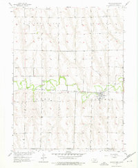
1957 Map of Lebanon
USGS Topo · Published 1976About this map
Beaver Creek meanders through this portion of the Kansas-Nebraska borderlands, serving as the central geographic feature of the Lebanon quadrangle. The village of Lebanon sits along the northern banks of the creek, situated at the intersection of local township boundaries. This mid-century landscape is defined by the Chicago Burlington and Quincy railroad, which follows the creek's valley and links the agricultural community to wider markets. North of the valley, the terrain rises toward Missouri Ridge, where the map records rural markers like School No 82. For genealogists, the map identifies specific burial sites including Hamburg Cem and Redman Cem, providing precise locations for family research within Beaver and Lebanon townships. The map reflects a period of stable rural settlement before modern infrastructure bypassed many of these small high-plains railroad towns.
Find a feature on this map
13 named features on this map. Tap any name to fly to it.
Don’t see what you’re looking for? This feature index may not catch every label — zoom into the map to look around manually.
Map Details
Editions of this 1957 Lebanon Map
3 editions found
Other maps of this area

1951 · Norcatur
USGS Topo · 1:62,500

1951 · Kanona
USGS Topo · 1:62,500

1954 · McCook
USGS Topo · 1:250,000

1954 · Goodland
USGS Topo · 1:250,000

1956 · Goodland
USGS Topo · 1:250,000

1957 · McCook
USGS Topo · 1:250,000

1957 · Goodland
USGS Topo · 1:250,000

1957 · Shippee
USGS Topo · 1:24,000

1957 · Danbury
USGS Topo · 1:24,000

1957 · Lebanon
USGS Topo · 1:24,000