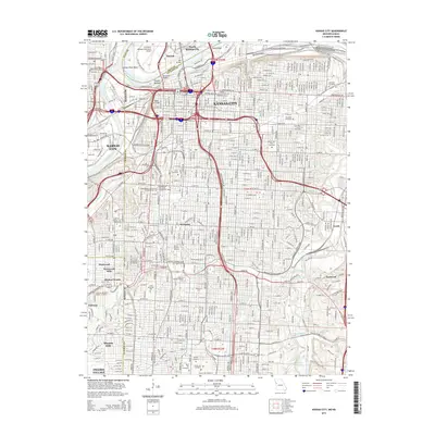
2015 Map of Kansas City
USGS Topo · Published 2015About this map
Kansas City and its core neighborhoods are captured here as they appeared in 2015, defined by the heavy infrastructure of the Missouri River and Kansas River confluence. The landscape is a dense assembly of historic districts like Westport and French Bottom, industrial hubs such as Leeds, and significant educational institutions including the Kansas City Art Institute and the University of Missouri-Kansas City. Transportation networks dominate the northern half, where the Charles B. Wheeler Downtown Airport sits within the Kansas River Bend, while several major crossings including the Paseo Bridge and Broadway Bridge link the downtown core to North Kansas City. Notable green spaces and legacy sites like Loose Memorial Park and Forest Hill Cemetery break the urban grid, offering a clear view of the city’s residential and memorial landscape as it transitioned into the mid-2010s.
Find a feature on this map
67 named features on this map. Tap any name to fly to it.
Don’t see what you’re looking for? This feature index may not catch every label — zoom into the map to look around manually.
Map Details
Editions of this 2015 Kansas City Map
This is the sole edition of this map. No revisions or reprints were ever made.
Other maps of this area

1887 · Harrisonville
USGS Topo · 1:125,000

1887 · Olathe
USGS Topo · 1:125,000

1890 · Kansas City
USGS Topo · 1:125,000

1892 · Harrisonville
USGS Topo · 1:125,000

1893 · Olathe
USGS Topo · 1:125,000

1894 · Kansas City
USGS Topo · 1:125,000

1894 · Harrisonville
USGS Topo · 1:125,000

1894 · Independence
USGS Topo · 1:125,000

1934 · Independence
USGS Topo · 1:24,000

1934 · Grandview
USGS Topo · 1:24,000