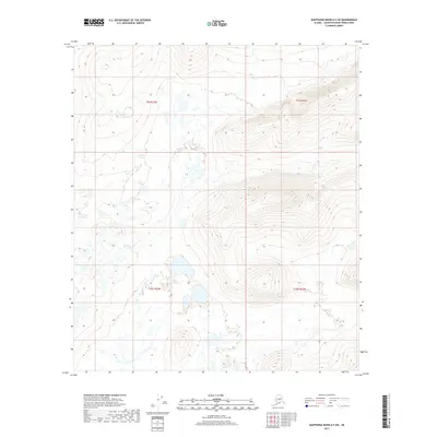
2017 Map of Kantishna River A-5 SW
USGS Topo · Published 2017About this map
Glacial landforms and intricate water networks characterize this section of the Yukon-Koyukuk Census Area in the early 21st century. The terrain is defined by an extensive system of small lakes, ponds, and wetlands that fill the low-lying basins between significant topographical rises. These natural features are organized within the Public Land Survey System divisions of T9s R25w, T9s R24w, T10s R25w, and T10s R24w. The 2017 survey reveals a landscape where elevation changes are marked by tight contour intervals on several prominent hills, contrasting sharply with the saturated flats below. This map is particularly useful for understanding the hydrologic patterns and natural drainage of the Alaskan interior, showing how water collects in the numerous unnamed basins across the quadrangle.
Find a feature on this map
4 named features on this map. Tap any name to fly to it.
Don’t see what you’re looking for? This feature index may not catch every label — zoom into the map to look around manually.
Map Details
Editions of this 2017 Kantishna River A-5 SW Map
This is the sole edition of this map. No revisions or reprints were ever made.
Other maps of this area

1948 · Kantishna River
USGS Topo · 1:250,000

1951 · Kantishna River
USGS Topo · 1:250,000

1952 · Mount McKinley
USGS Topo · 1:250,000

1952 · Kantishna River
USGS Topo · 1:250,000

1952 · Kantishna River A-5
USGS Topo · 1:63,360

1952 · Kantishna River A-6
USGS Topo · 1:63,360

1953 · Mount McKinley D-5
USGS Topo · 1:63,360
1953 · Kantishna River A-6
USGS Topo · 1:63,360

1954 · Mount McKinley D-5
USGS Topo · 1:63,360

1958 · Mount McKinley D-6
USGS Topo · 1:63,360