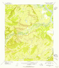
1954 Map of Kantishna River D-4
USGS Topo · Published 1956About this map
The Tanana River anchors the northeast corner of this 1950s landscape, where it interacts with a complex network of waterways including Harper Bend and Williams Slough. The topography is dominated by the winding course of the Chitanana River, which meanders across the central and southern portions of the territory before meeting the Cosna River. Surveyors in 1954 established several triangulation points across the high ground, notably VABM 966 Nana and VABM 512 Whisper. This survey captures a wild, unpopulated interior region of Alaska characterized by intricate oxbow lakes and sediment-heavy river braids, providing a clear record of the drainage patterns and landforms before more modern navigational or infrastructure changes.
Find a feature on this map
8 named features on this map. Tap any name to fly to it.
Don’t see what you’re looking for? This feature index may not catch every label — zoom into the map to look around manually.
Map Details
Editions of this 1954 Kantishna River D-4 Map
This is the sole edition of this map. No revisions or reprints were ever made.
Other maps of this area

1948 · Kantishna River
USGS Topo · 1:250,000

1951 · Kantishna River
USGS Topo · 1:250,000

1951 · Tanana
USGS Topo · 1:250,000

1952 · Tanana A-3
USGS Topo · 1:63,360

1952 · Tanana A-4
USGS Topo · 1:63,360

1952 · Kantishna River C-5
USGS Topo · 1:63,360

1952 · Kantishna River D-5
USGS Topo · 1:63,360

1952 · Kantishna River
USGS Topo · 1:250,000

1952 · Tanana A-5
USGS Topo · 1:63,360

1952 · Kantishna River D-3
USGS Topo · 1:63,360