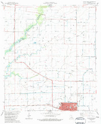
1983 Map of Kaplan North
USGS Topo · Published 1983About this map
The low-lying coastal prairies of Vermilion Parish are defined by an intricate network of drainage and irrigation in this early 1980s study. The northern outskirts of Kaplan serve as the primary hub, where the Southern Pacific railroad corridor meets local institutions like Kaplan High Sch and the Abrom Mem Hospital. This landscape is deeply rooted in family history, evidenced by numerous private landing strips such as Meaux Landing Strip and Abshire Landing Strip, which speak to the area's agricultural aviation and expansive landholdings.
Find a feature on this map
29 named features on this map. Tap any name to fly to it.
Don’t see what you’re looking for? This feature index may not catch every label — zoom into the map to look around manually.
Map Details
Editions of this 1983 Kaplan North Map
This is the sole edition of this map. No revisions or reprints were ever made.
Other maps of this area

1932 · Abbeville NW
USGS Topo · 1:31,680

1934 · Duson
USGS Topo · 1:31,680

1946 · Morse
USGS Topo · 1:31,680

1946 · Leroy
USGS Topo · 1:31,680

1946 · Schooner Bayou NE
USGS Topo · 1:31,680

1946 · Schooner Bayou NW
USGS Topo · 1:31,680

1946 · Kaplan
USGS Topo · 1:31,680

1946 · Rayne
USGS Topo · 1:31,680

1949 · Estherwood
USGS Topo · 1:31,680

1952 · Lake Charles
USGS Topo · 1:250,000