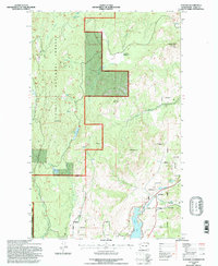
1992 Map of Karamin
USGS Topo · Published 1996About this map
The Colville National Forest dominates this landscape in northeastern Washington, where the high ridges of Granite Mountain and Mt Elizabeth overlook a network of creek drainages and high-elevation meadows. The settlement at Karamin sits along the southern edge of the sheet, situated near where Curlew Creek feeds into the northern reaches of Curlew Lake. This 1990s revision by the Forest Service and U.S. Geological Survey delineates complex land management boundaries, including numerous Indian Allotment parcels that interleave with public forest lands.
Find a feature on this map
25 named features on this map. Tap any name to fly to it.
Don’t see what you’re looking for? This feature index may not catch every label — zoom into the map to look around manually.
Map Details
Editions of this 1992 Karamin Map
This is the sole edition of this map. No revisions or reprints were ever made.
Other maps of this area

1904 · Republic
USGS Topo · 1:125,000

1948 · Curlew
USGS Topo · 1:62,500

1948 · Republic
USGS Topo · 1:62,500

1951 · Wauconda
USGS Topo · 1:62,500

1951 · Curlew
USGS Topo · 1:62,500

1951 · Bodie Mountain
USGS Topo · 1:62,500

1951 · Republic
USGS Topo · 1:62,500

1954 · Okanogan
USGS Topo · 1:250,000

1958 · Okanogan
USGS Topo · 1:250,000

1958 · Aeneas
USGS Topo · 1:62,500