
1929 Map of Karthaus
USGS Topo · Published 1955About this map
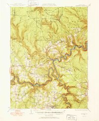
Karthaus sits at a sharp bend in the West Branch of the Susquehanna River, serving as a focal point for this 1929 survey of the rugged Pennsylvania coal and lumber country. The landscape is defined by deep drainages like Mosquito Creek and Moshannon Creek, which carved the plateaus where numerous small farming and mining communities took root. Settlements such as the Granot Settlement and Cooper Settlement illustrate the late 19th and early 20th-century pattern of upland ethnic hamlets, often anchored by local institutions like the German Settlement Sch or Sylvan Grove Sch.
Find a feature on this map
116 named features on this map. Tap any name to fly to it.
Don’t see what you’re looking for? This feature index may not catch every label — zoom into the map to look around manually.
Map Details
Editions of this 1929 Karthaus Map
3 editions found

Historical Maps of Karthaus Township Through Time
30 maps found
1929 Karthaus
Clearfield County, PA

1929 Penfield
Clearfield County, PA

1932 Karthaus
Clearfield County, PA

1932 Penfield
Clearfield County, PA

1944 Glen Richey
Clearfield County, PA

1946 Glen Richey
Clearfield County, PA

1959 Devils Elbow
Clearfield County, PA

1959 Elliott Park
Clearfield County, PA

1959 Frenchville
Clearfield County, PA

1959 Huntley
Clearfield County, PA

1959 Lecontes Mills
Clearfield County, PA

1959 Luthersburg
Clearfield County, PA

1959 Penfield
Clearfield County, PA

1959 Sabula
Clearfield County, PA

1959 The Knobs
Clearfield County, PA

1968 Mc Gees Mills
Clearfield County, PA

1993 Glen Richey
Clearfield County, PA

1993 Penfield
Clearfield County, PA

2000 Lecontes Mills
Clearfield County, PA

2023 Devils Elbow
Clearfield County, PA

2023 Elliott Park
Clearfield County, PA

2023 Frenchville
Clearfield County, PA

2023 Glen Richey
Clearfield County, PA

2023 Huntley
Clearfield County, PA

2023 Lecontes Mills
Clearfield County, PA

2023 Luthersburg
Clearfield County, PA

2023 McGees Mills
Clearfield County, PA

2023 Penfield
Clearfield County, PA

2023 Sabula
Clearfield County, PA

2023 The Knobs
Clearfield County, PA
Featured Locations
- Rush Township, PA
- Karthaus Township, PA
- Benezette Township, PA
- Moshannon, Snow Shoe Township
- Rolling Stone, Covington Township