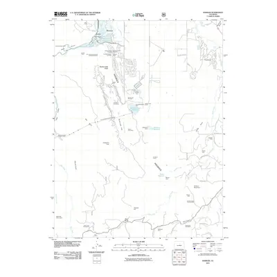
2011 Map of Kassler
USGS Topo · Published 2011About this map
The South Platte River enters this landscape through the narrow Canyon at Waterton, where the Platte Canyon Reservoir and Platte Canyon Dam manage the vital water flow near the Foothills Treatment Plant. This era shows a complex industrial and residential balance along the prominent north-south Hogback ridge. Extensive mining activity is evident, from the cluster of Hogback Number Two Mine and Hogback Number Three Mine to the Helmer Lime Quarry further south. The settlement at Louviers sits east of the ridge, while developments like Roxborough Park sit tucked against the terrain near the Arrowhead Golf Course. The map traces essential infrastructure including the Highline Canal and modern utility features such as Aurora Rampart Tunnel Number 2, showing the ongoing engineering required to support this community.
Find a feature on this map
77 named features on this map. Tap any name to fly to it.
Don’t see what you’re looking for? This feature index may not catch every label — zoom into the map to look around manually.
Map Details
Editions of this 2011 Kassler Map
This is the sole edition of this map. No revisions or reprints were ever made.
Other maps of this area

1890 · East Denver
USGS Topo · 1:125,000

1893 · Platte Canyon
USGS Topo · 1:125,000

1894 · Castle Rock
USGS Topo · 1:125,000

1899 · West Denver
USGS Topo · 1:125,000

1913 · Castle Rock
USGS Topo · 1:125,000

1935 · East Denver Nos. 3 and 4
USGS Topo · 1:48,000

1940 · Castle Rock
USGS Topo · 1:62,500

1942 · Highland Ranch
USGS Topo · 1:31,680

1942 · Littleton
USGS Topo · 1:31,680

1945 · Castle Rock
USGS Topo · 1:62,500