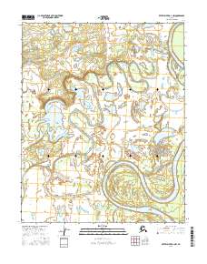
2016 Map of Kateel River D-1 NW
USGS Topo · Published 2016About this map
The Koyukuk River dominates this northern Alaskan interior landscape, its complex oxbows and meanders illustrating the dynamic hydrology of the Yukon-Koyukuk region. In this 2016 survey, the river is shown as it winds through a vast network of wetlands and seasonal water bodies within the townships of T7n R11e, T7n R12e, T6n R11e, and T6n R12e. The intricate pattern of sloughs and abandoned channels reveals a shifting alluvial environment where the main channel frequently alters its course over time. This map serves as a highly detailed baseline for studying river morphology and the subsistence-rich wetlands that define this part of the Alaskan wilderness. Outside of the river itself, the map is remarkably sparse, focusing almost entirely on the natural hydrography and elevation contours that dictate the seasonal flow of the drainage basin.
Find a feature on this map
5 named features on this map. Tap any name to fly to it.
Don’t see what you’re looking for? This feature index may not catch every label — zoom into the map to look around manually.
Map Details
Editions of this 2016 Kateel River D-1 NW Map
This is the sole edition of this map. No revisions or reprints were ever made.
Other maps of this area

1951 · Shungnak
USGS Topo · 1:250,000

1951 · Kateel River
USGS Topo · 1:250,000

1954 · Kateel River D-1
USGS Topo · 1:63,360

1955 · Shungnak
USGS Topo · 1:250,000

1955 · Kateel River D-2
USGS Topo · 1:63,360

1955 · Kateel River
USGS Topo · 1:250,000

1964 · Shungnak
USGS Topo · 1:250,000
1985 · Shungnak A-1
USGS Topo · 1:63,360
1985 · Shungnak A-2
USGS Topo · 1:63,360
2016 · Kateel River D-2 SE
USGS Topo · 1:25,000