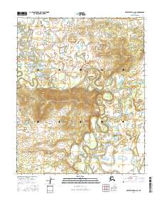
2016 Map of Kateel River D-2 NE
USGS Topo · Published 2016About this map
Huslia River dominates this interior Alaska landscape, carving a complex network of oxbow lakes and abandoned meander loops across the central and eastern portions of the terrain. The river’s winding course illustrates the dynamic nature of northern alluvial systems, where seasonal flooding and permafrost continuously reshape the banks. In the western reaches, the South Fork Huslia River joins the drainage system, while Billy Hawk Creek drains the north-northwest. This area, delineated by the survey boundaries of t7n r10e, t7n r11e, t6n r10e, and t6n r11e, remains largely unsettled, showing the raw hydrological patterns of the Yukon-Koyukuk region before significant human infrastructure altered the natural flow.
Find a feature on this map
7 named features on this map. Tap any name to fly to it.
Don’t see what you’re looking for? This feature index may not catch every label — zoom into the map to look around manually.
Map Details
Editions of this 2016 Kateel River D-2 NE Map
This is the sole edition of this map. No revisions or reprints were ever made.
Other maps of this area

1951 · Shungnak
USGS Topo · 1:250,000

1951 · Kateel River
USGS Topo · 1:250,000

1954 · Kateel River D-1
USGS Topo · 1:63,360

1955 · Shungnak
USGS Topo · 1:250,000

1955 · Kateel River D-2
USGS Topo · 1:63,360

1955 · Kateel River
USGS Topo · 1:250,000

1964 · Shungnak
USGS Topo · 1:250,000
1985 · Shungnak A-1
USGS Topo · 1:63,360
1985 · Shungnak A-2
USGS Topo · 1:63,360
2016 · Kateel River D-2 SE
USGS Topo · 1:25,000