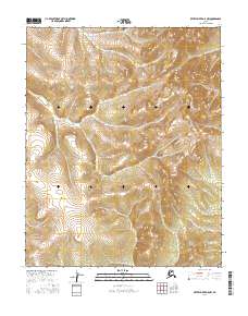
2016 Map of Kateel River D-5 NW
USGS Topo · Published 2016About this map
The Continental Divide winds across this interior Alaskan landscape, marking the hydrologic boundary within the Kateel River region. This 2016 survey, published by the U.S. Geological Survey, focuses on a remote high-altitude terrain defined by intricate contour patterns and deep drainages. The landscape is largely untouched by modern infrastructure, showing no roads, settlements, or named structures, which highlights the area's wild character in the early 21st century.
Find a feature on this map
5 named features on this map. Tap any name to fly to it.
Don’t see what you’re looking for? This feature index may not catch every label — zoom into the map to look around manually.
Map Details
Editions of this 2016 Kateel River D-5 NW Map
This is the sole edition of this map. No revisions or reprints were ever made.
Other maps of this area

1951 · Shungnak
USGS Topo · 1:250,000

1951 · Kateel River
USGS Topo · 1:250,000

1954 · Kateel River D-6
USGS Topo · 1:63,360

1954 · Kateel River D-5
USGS Topo · 1:63,360

1955 · Shungnak
USGS Topo · 1:250,000

1955 · Kateel River
USGS Topo · 1:250,000

1964 · Shungnak
USGS Topo · 1:250,000
1985 · Shungnak A-5
USGS Topo · 1:63,360
1985 · Shungnak A-6
USGS Topo · 1:63,360
2015 · Kateel River D-6 SE
USGS Topo · 1:25,000