
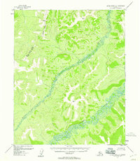
1954 Map of Kateel River D-5
USGS Topo · Published 1966About this map
The Continental Divide defines the primary drainage patterns across this interior Alaskan landscape, which was mapped via photogrammetric methods from aerial surveys in the early 1950s. The terrain transitions from higher elevations along the divide into a complex network of lowland marshes and small ponds in the eastern portion of the quadrangle. In the southeastern corner, the South Fork Huslia River carves through the terrain, representing the principal waterway of the region. This survey captures a moment in the mid-20th century before any significant roads or trails were established in this section of the Yukon-Koyukuk region, reflecting the immense isolation of the Alaskan interior at the time.
Find a feature on this map
2 named features on this map. Tap any name to fly to it.
Don’t see what you’re looking for? This feature index may not catch every label — zoom into the map to look around manually.
Map Details
Editions of this 1954 Kateel River D-5 Map
This is the sole edition of this map. No revisions or reprints were ever made.
Other maps of this area

1951 · Shungnak
USGS Topo · 1:250,000

1951 · Kateel River
USGS Topo · 1:250,000

1954 · Kateel River C-4
USGS Topo · 1:63,360

1954 · Kateel River D-4
USGS Topo · 1:63,360

1954 · Kateel River D-6
USGS Topo · 1:63,360

1954 · Kateel River C-6
USGS Topo · 1:63,360

1955 · Shungnak
USGS Topo · 1:250,000
1955 · Kateel River C-5
USGS Topo · 1:63,360

1955 · Kateel River
USGS Topo · 1:250,000

1964 · Shungnak
USGS Topo · 1:250,000