
1954 Map of Kateel River D-6
USGS Topo · Published 1965About this map
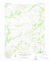
The Tagagawik River meanders through this interior Alaska wilderness, serving as the primary geographical feature of a landscape largely defined by its water systems and elevation contours. Flowing from the south and curving westward, the river is joined by the winding course of Derby Creek, which cuts through the central terrain. This 1954 survey provides a record of a remote region where land lines remained largely unsurveyed and unmarked, as noted by the Bureau of Land Management. The map is bisected by the Principal Meridian, a critical baseline for the rectangular survey system in the Kateel River Meridian area. The absence of named settlements or roads underscores the wilderness character of the territory during the mid-1950s, focusing instead on the intricate drainage patterns and the relief of the surrounding hills as captured through early photogrammetric methods.
Find a feature on this map
4 named features on this map. Tap any name to fly to it.
Don’t see what you’re looking for? This feature index may not catch every label — zoom into the map to look around manually.
Map Details
Editions of this 1954 Kateel River D-6 Map
2 editions found
Other maps of this area

1951 · Candle
USGS Topo · 1:250,000

1951 · Selawik
USGS Topo · 1:250,000

1951 · Shungnak
USGS Topo · 1:250,000

1951 · Kateel River
USGS Topo · 1:250,000
1954 · Candle D-1
USGS Topo · 1:63,360

1954 · Candle C-1
USGS Topo · 1:63,360

1954 · Kateel River D-5
USGS Topo · 1:63,360

1954 · Kateel River C-6
USGS Topo · 1:63,360

1955 · Shungnak
USGS Topo · 1:250,000
1955 · Kateel River C-5
USGS Topo · 1:63,360