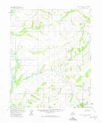
1954 Map of Kateel River D-6
USGS Topo · Published 1974About this map
Tagagawik River meanders through this portion of the interior, creating a complex network of wetlands and oxbows typical of the northern Alaskan drainage basins. The map illustrates a landscape defined by water and topography rather than human settlement, where Derby Creek flows into the river system amidst a series of rising hills and ridge lines. Surveying of this region was complex, as evidenced by the Principal Meridian cutting vertically through the center of the sheet, providing a primary reference point for the Bureau of Land Management in a territory where land lines represented unsurveyed and unmarked locations. This mid-century survey captures the region in its natural state, devoid of roads or trails, where the land was defined strictly by its geological and hydrological contours.
Find a feature on this map
4 named features on this map. Tap any name to fly to it.
Don’t see what you’re looking for? This feature index may not catch every label — zoom into the map to look around manually.
Map Details
Editions of this 1954 Kateel River D-6 Map
2 editions found
Other maps of this area

1951 · Candle
USGS Topo · 1:250,000

1951 · Selawik
USGS Topo · 1:250,000

1951 · Shungnak
USGS Topo · 1:250,000

1951 · Kateel River
USGS Topo · 1:250,000
1954 · Candle D-1
USGS Topo · 1:63,360

1954 · Candle C-1
USGS Topo · 1:63,360

1954 · Kateel River D-6
USGS Topo · 1:63,360

1954 · Kateel River D-5
USGS Topo · 1:63,360

1954 · Kateel River C-6
USGS Topo · 1:63,360

1955 · Shungnak
USGS Topo · 1:250,000