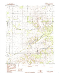
1985 Map of Shungnak A-6
USGS Topo · Published 1985About this map
The Continental Divide and Koyukuk Divide dominate this remote northern landscape, marking the critical watershed where interior drainage shifts across the terrain. Much of the western territory is preserved within the Selawik National Wildlife Refuge, an area defined by its complex hydrology and absence of roads. The map follows the meandering courses of the Tagagawik River and the Kateel River, which carve through the wilderness south of the Arctic Circle. This 1985 provisional edition by the Geological Survey reflects the land management boundaries established by the Alaska National Interest Lands Conservation Act, positioning the Kateel River Meridian as the primary surveying reference for this undeveloped region.
Find a feature on this map
6 named features on this map. Tap any name to fly to it.
Don’t see what you’re looking for? This feature index may not catch every label — zoom into the map to look around manually.
Map Details
Editions of this 1985 Shungnak A-6 Map
This is the sole edition of this map. No revisions or reprints were ever made.
Other maps of this area

1951 · Candle
USGS Topo · 1:250,000

1951 · Selawik
USGS Topo · 1:250,000

1951 · Shungnak
USGS Topo · 1:250,000

1951 · Kateel River
USGS Topo · 1:250,000
1954 · Candle D-1
USGS Topo · 1:63,360

1954 · Kateel River D-6
USGS Topo · 1:63,360

1954 · Kateel River D-5
USGS Topo · 1:63,360

1955 · Shungnak
USGS Topo · 1:250,000

1955 · Kateel River
USGS Topo · 1:250,000

1955 · Candle
USGS Topo · 1:250,000