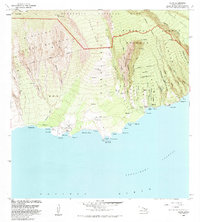
1983 Map of Kaupo
USGS Topo · Published 1983About this map
Haleakala National Park dominates the northern reaches of this coastal landscape, where the dramatic descent from the Haleakala Crater meets the Alenuihaha Channel. This area of Maui is defined by its deep cultural history, evidenced by the presence of significant religious sites such as Loaloa Heiau, Popoiwi Heiau, and Hale O Kane Heiau near the settlement of Kaupo. The map details a transition from high volcanic terrain through the Kipahulu Forest Reserve down to the sea, where historic maritime activity is noted at Mokulau Landing and Nuu Landing. Genealogical interest is found within the Kaupo Homesteads and Kalepa Homesteads, while the Kaupo Trail provides a historical route through the Kaupo Gap. The southern coastline is punctuated by numerous named points and bays, from Huakini Bay to Kalepa Pt.
Find a feature on this map
81 named features on this map. Tap any name to fly to it.
Don’t see what you’re looking for? This feature index may not catch every label — zoom into the map to look around manually.
Map Details
Editions of this 1983 Kaupo Map
This is the sole edition of this map. No revisions or reprints were ever made.
Other maps of this area

1954 · Maui
USGS Topo · 1:250,000

1957 · Kilohana
USGS Topo · 1:24,000

1957 · Kipahulu
USGS Topo · 1:24,000

1957 · Hana
USGS Topo · 1:24,000

1957 · Lualailua Hills
USGS Topo · 1:24,000

1957 · Nahiku
USGS Topo · 1:24,000

1957 · Kaupo
USGS Topo · 1:24,000

1966 · Maui
USGS Topo · 1:250,000

1974 · Maui
USGS Topo · 1:250,000

1978 · Hana
USGS Topo · 1:24,000