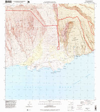
1996 Map of Kaupo
USGS Topo · Published 1999About this map
Haleakala National Park dominates the northern reaches of this coastal landscape, where the southern rim of the Haleakala Crater descends toward the Alenuihaha Channel. This 1990s survey preserves the layout of the Kaupo Homesteads and Kalepa Homesteads, representing a significant era of native land tenure and rural development on Maui. The map illustrates a rugged coastal economy defined by historic points of access, including Nuu Landing and Mokulau Landing.
Find a feature on this map
75 named features on this map. Tap any name to fly to it.
Don’t see what you’re looking for? This feature index may not catch every label — zoom into the map to look around manually.
Map Details
Editions of this 1996 Kaupo Map
This is the sole edition of this map. No revisions or reprints were ever made.
Other maps of this area

1954 · Maui
USGS Topo · 1:250,000

1957 · Kilohana
USGS Topo · 1:24,000

1957 · Kipahulu
USGS Topo · 1:24,000

1957 · Hana
USGS Topo · 1:24,000

1957 · Lualailua Hills
USGS Topo · 1:24,000

1957 · Nahiku
USGS Topo · 1:24,000

1957 · Kaupo
USGS Topo · 1:24,000

1966 · Maui
USGS Topo · 1:250,000

1974 · Maui
USGS Topo · 1:250,000

1978 · Hana
USGS Topo · 1:24,000